
Magnetic Declination
(What do you mean "North isn't North")
[FRANÇAIS]
|
Magnetic Declination(What do you mean "North isn't North") |
[FRANÇAIS] |
Many people are surprised to learn that a magnetic compass does not normally point to true north. In fact, over most of the Earth it points at some angle east or west of true (geographic) north. The direction in which the compass needle points is referred to as magnetic north, and the angle between magnetic north and the true north direction is called magnetic declination. You will often hear the terms "variation", "magnetic variation", or "compass variation" used in place of magnetic declination, especially by mariners.
The magnetic declination does not remain constant in time. Complex 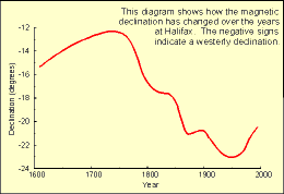 fluid motion in the outer core of the Earth (the molten metallic
region that lies from 2800 to 5000 km below the Earth's surface) causes the
magnetic field to change slowly with time. This change is known to as
secular variation. An an example, the accompanying diagram
shows how the magnetic declination has changed with time at Halifax. Because of
secular variation, declination values shown on old topographic, marine and
aeronautical charts need to be updated if they are to be used without large
errors. Unfortunately, the annual change corrections given on most of these maps
cannot be applied reliably if the maps are more than a few years old since the
secular variation also changes with time in an unpredictable manner. If accurate
declination values are needed, and if recent editions of the charts are not
available, up-to-date values for Canada may be obtained from the most recent geomagnetic reference
field models produced by the Geological Survey of Canada.
fluid motion in the outer core of the Earth (the molten metallic
region that lies from 2800 to 5000 km below the Earth's surface) causes the
magnetic field to change slowly with time. This change is known to as
secular variation. An an example, the accompanying diagram
shows how the magnetic declination has changed with time at Halifax. Because of
secular variation, declination values shown on old topographic, marine and
aeronautical charts need to be updated if they are to be used without large
errors. Unfortunately, the annual change corrections given on most of these maps
cannot be applied reliably if the maps are more than a few years old since the
secular variation also changes with time in an unpredictable manner. If accurate
declination values are needed, and if recent editions of the charts are not
available, up-to-date values for Canada may be obtained from the most recent geomagnetic reference
field models produced by the Geological Survey of Canada.
![]()
 The Magnetic Compass
 The magnetic compass has been used for navigation for hundreds of years. At one time, it was the only reliable means of direction-finding on days when the sun and stars were not visible. Nowadays, sophisticated equipment is available that enables users to determine their bearing accurately and to pinpoint locations to within a few metres. However, such equipment has not made the compass obsolete. It is still a very practical tool for navigation for many small craft and for people on foot. Even airplanes and ships equipped with more sophisticated equipment often carry compasses as backups.
Compasses come in a variety of shapes and sizes depending on their intended use. The type of compass used on a ship or aircraft is a complex device capable of compensating for both the motion of the craft and its metallic structure. At the other extreme are small pocket compasses of low precision intended for casual use.
Regardless of their intended purpose or the complexity of their construction, most compasses operate on the same basic principle. A small, elongated, permanently magnetized needle is placed on a pivot so that it may rotate freely in the horizontal plane. The Earth's magnetic field which is shaped approximately like the field around a simple bar magnet exerts forces on the compass needle, causing it to rotate until it comes to rest in the same horizontal direction as the magnetic field. Over much of the Earth, this direction is roughly true north, which accounts for the compass's importance for navigation.
 The horizontal force of
the magnetic field, responsible for the direction in which a compass needle is
oriented, decreases in strength as one approaches the North Magnetic
Pole, where it is zero. Close to the pole, an area is reached where the
frictional forces in the pivot are comparable to the horizontal forces of the
magnetic field. The compass starts to behave erratically, and eventually, as the
horizontal force decreases even more, the compass becomes unusable.
The horizontal force of
the magnetic field, responsible for the direction in which a compass needle is
oriented, decreases in strength as one approaches the North Magnetic
Pole, where it is zero. Close to the pole, an area is reached where the
frictional forces in the pivot are comparable to the horizontal forces of the
magnetic field. The compass starts to behave erratically, and eventually, as the
horizontal force decreases even more, the compass becomes unusable.
Since magnetic observations are neither uniformly nor densely distributed
over the Earth, and since the magnetic field is constantly changing in time, it
is not possible to obtain up-to-date values of declination directly from a
database of past observations. Instead, the data are analyzed to produce a
mathematical routine called a magnetic reference field "model", from which
magnetic declination can be calculated. Global models are produced every five
years. These constitute the series of International Geomagnetic
Reference Field
(IGRF) models. The latest IGRF was produced in 1995, and is valid until
2000. The Canadian
Geomagnetic Reference Field (CGRF) is a model of the magnetic field over the
Canadian region. It was produced using denser data over Canada than were used
for the IGRF, and because the 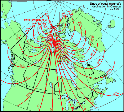 analysis was
carried out over a smaller region, the CGRF can reproduce smaller spatial
variations in the magnetic field than can the IGRF. The latest CGRF was also
produced in 1995 and is valid until 2000. The accompanying declination chart is
based on the CGRF.
analysis was
carried out over a smaller region, the CGRF can reproduce smaller spatial
variations in the magnetic field than can the IGRF. The latest CGRF was also
produced in 1995 and is valid until 2000. The accompanying declination chart is
based on the CGRF.
Since magnetic field models such as the IGRF and CGRF are approximations to observed data, a value of declination computed using either of them is likely to differ somewhat from the "true" value at that location. It is generally agreed that the IGRF achieves an overall accuracy of better than 1° in declination; the accuracy is better than this in densely surveyed areas such as Europe and North America, and worse in oceanic areas such as the south Pacific. The accuracy of the CGRF, in southern Canada, is about 0.5°. The accuracy of all models decreases in the Arctic near the North Magnetic Pole.
Magnetic field models are used to calculate magnetic declination by means of computer programs such as the Magnetic Information Retrieval Program (MIRP), a software package developed by the Geomagnetism Program of the Geological Survey of Canada. The user inputs the year, latitude and longitude and MIRP calculates the declination. MIRP is able to compute values for any location on the Earth in the time period 1960 to 2000. For locations within Canada, MIRP computes values using the CGRF. Outside Canada, values are calculated using the IGRF.
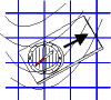
| Navigating by compass requires determining
bearings with respect to true or grid north from a map sheet and
converting them to magnetic bearings for use with a compass. One way of
doing this is given in the following steps.
1) Place the compass on the map with the direction-of-travel arrow
pointing along the desired line of travel. 2) Rotate the compass dial so that the parallel lines within the capsule line up with the grid lines on the map. Convert the grid bearing to a magnetic bearing using the information given (as in the accompanying diagram) on the map sheet. If declination is west, add it to the grid bearing; if declination is east, subtract it from the grid bearing. Adjust the dial to read the value of the magnetic bearing opposite the direction of travel arrow. Make certain to account for the difference between grid north and true north. 3) Now pick up and rotate the |
For further information contact: Larry Newitt
| Geological Survey of Canada National Geomagnetism Program #7 Observatory Crescent Ottawa, Ontario,Canada K1A 0Y3 |
||

Comments: webmaster
1999/09/08 jap![]()
 whole
compass until the red end of the needle points to the north marker on the
dial. The direction-of-travel arrow on the compass card will point to your
destination. Choose a landmark in that direction and walk towards it.
whole
compass until the red end of the needle points to the north marker on the
dial. The direction-of-travel arrow on the compass card will point to your
destination. Choose a landmark in that direction and walk towards it.